| As a result of 300 m deep drilling carried out by Shinshu University in 2008 in Kamikochi, it was found that an enormous dammed lake once existed. The damming occurred 12,000 years ago, in a period when there was sudden global warming. There was a major eruption of the Yakedake volcano group, resulting in damming of the old Azusa River which used to flow into the Takahara River in Gifu Prefecture (the Jinzu River system), thereby producing an enormous dammed lake – the old Kamikochi Lake. The landform of the present flat Kamikochi was formed by gradual reclamation of this lake over a period of 5,000 years or more. By analyzing pollen contained in the layers deposited in the dammed lake, mountain region’s warming, changing from grassland with no trees into a coniferous forest region and then into a deciduous broadleaf forest region over a period of 5,000 years was found out. About 5,000 years ago an earthquake occurred in the Sakai-Toge Fault which extends along the course of the Azusa River, causing a breach of old Kamikochi Lake. As a result of this breach, a large quantity of the sand and gravel that was accumulated in the lake was swept downstream into the Azusa River with the huge flood waters, and formed Maruta Terrace which spreads out as the lowest terrace on the north side of Azusa Rive from Maruta in Matsumoto City to Toyoshina in Azumino City. As a result of this scientific drilling and subsequent research it was found that there were major changes in the river systems and topography of the Northern Japan Alps, changes in the mountainous environment after the last glacial stage, and an enormous flooding into the Matsumoto Basin caused by the earthquake. |
|

Kamikochi was formerly a deep V-shaped valley in the mountain range, but 12,000 years ago an enormous lake was suddenly formed
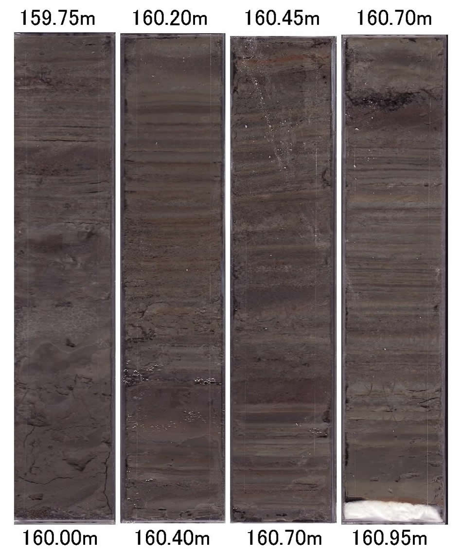
| Around 290-300 m depth of the scientific drilling which is at its deepest, riverbed gravel and sand strata of the old Azusa river were found. Because the diameter of the rounded riverbed gravel reaches 50 cm, it was considered that this was a rapid V-shaped valley flow flowing down to the Gifu Prefecture side. This damming of the old Azusa River which flowed down to the Gifu Prefecture side occurred 12,000 years ago during the early Jomon Period. That was a period when the last glacial stage was over and the world was warming. A major eruption by one of the Yakedake Volcano group, Shirataniyama Volcano, occurred 12,000 years ago, and after the pyroclastic flow the volcanic edifice collapsed. This eruption dammed the old Azusa River which used to flow into the Takahara River (Jinzu River system) through Hirayu area of Gifu Prefecture back then. As a result, an enormous dammed lake with a depth of 400 m, length 12 km, and a width of 2 km was formed. |
|
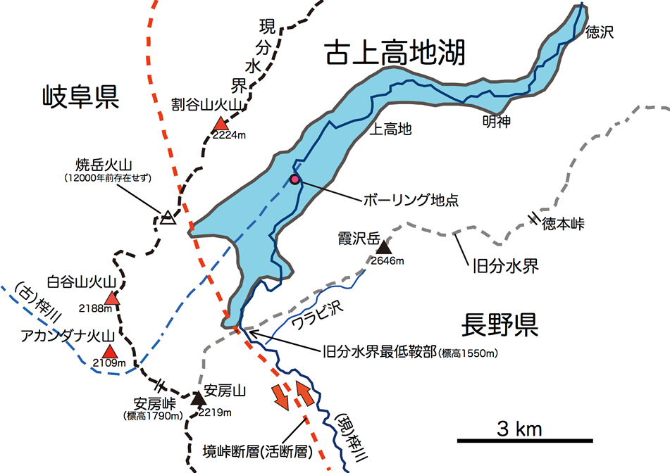
The Old Kamikochi Lake existed for more than 5,000 years from 12,000 to 7,000 years ago
| Scientific borehole at depths from 290 m to 114 m consist of silt, clay, and sandy gravel strata which accumulated in the bottom of the lake. Sand and gravel carried by flood flows of the Azusa River and mud flows of Yakedake flowed into the dammed lake from time to time, but at other times silt and clay strata indicating a calm environment were deposited in a varved pattern showing seasonal changes. This lake was gradually filled over a period of 5,000 years or more, thereby creating the form of the present flat Kamikochi. |
|
Rapid warming indicated by the varved deposits from the dammed lake
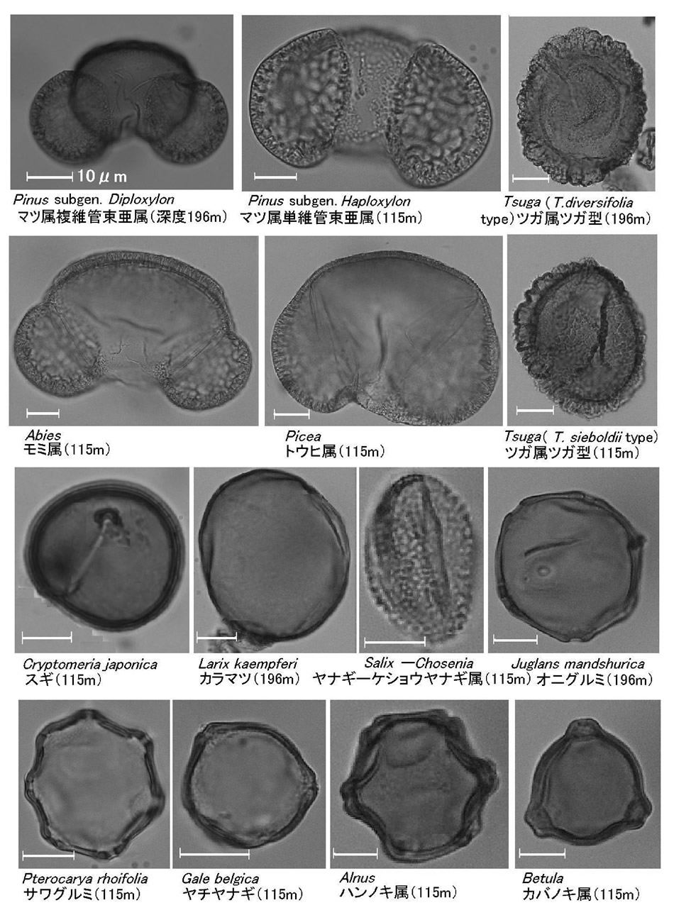
| From analysis of the pollen included in the varved silt and clay strata deposited in the dammed lake, it was found that the vegetation changed from desolate grassland with no forest to the formation of coniferous forest region, then to a deciduous broadleaf forest region. Immediately after damming, spores and non-arboreal pollen are predominant, indicating that an alpine meadow had been developed. Also, it was found that 12,000 years ago subalpine low trees such as Alnus japonica developed, about 11,000 years ago a subalpine coniferous forest that included spruce and fir, etc., developed, and from 10,000 to 7,000 years ago a deciduous tree forest that included Japanese beech (buna), konara oak, etc., developed. In present Kamikochi, coniferous trees form a climax forest which indicates that the climate was warmer about 7,000 years ago, corresponding to the warm period of the Jomon transgression at coastal plains. |
|
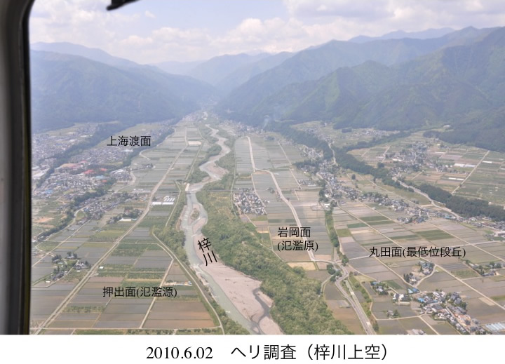
The breach of the enormous dammed lake and the enormous flood flow that affected the Matsumoto Basin
| About 5,000 years ago an earthquake occurred on the Sakai-Toge Fault which extends along the course of the Azusa River, causing old Kamikochi Lake to breach. As a result of this breach, a large quantity of the sand and gravel that had accumulated in the lake was swept downstream into the Azusa River with the huge flood waters, and reached the Matsumoto Basin. The enormous flood waters that flowed into the basin spread into the belt from the present Azusa Matsumoto City to Toyoshina Azumino City, and the large quantity of transported material was deposited to a depth of 10 m or more. The material deposited at then formed the Maruta Terrace which spreads out at the lowest position on the north side of present Azusa River. The sand and gravel derived from upstream of Kamikochi that was trapped by the old Kamikochi Lake was supplied to the Matsumoto Basin after this breach by the Azusa River. Because remains of the Middle Jomon Period and later have been found on the surface of Maruta Terrace, and since they moved to this area after the great flood, it indicates that this great flood occurred about 5,000 years ago. |
|